U.S. flag An official website of the United States government.
dot gov Official websites use .gov
A .gov website belongs to an official government organization in the United States.

https Secure websites use HTTPS
A small lock () or https:// means you've safely connected to a .gov website. Share sensitive          information only on official, secure websites.

Chart Downloader for NOAA ENC®

The Electronic Navigational Charts are available in S-57 format.

User's Agreement to Terms and Conditions.

There are several options for downloading:

1. Select a zip file of an Individual ENC from a list sorted by name.
2. Select a zip file of an Individual ENC from a list sorted by date.
3. Write an application or script that uses the data in the ENC Product Catalog, an XML file that contains the status of the ENCs available for download.
4. Select one of the pre-packaged zip files below:

All ENCs:
NameXMLSizeZip File Date Time*
AllView784 MB06/08/2026 05:28:24
Ten DaysN/A56 MB06/08/2026 05:33:07
One WeekN/A48 MB06/08/2026 05:32:18
Two DaysN/A0 MB06/08/2026 05:33:08
One DayN/A0 MB06/08/2026 05:32:04

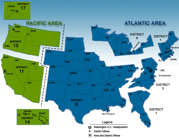
ENCs by Coast Guard Districts (map):
NameXMLSizeZip File Date Time* NameXMLSizeZip File Date Time* NameXMLSizeZip File Date Time*
01 CGDView99 MB06/08/2026 05:18:54 05 CGDView85 MB06/08/2026 05:20:39 07 CGDView88 MB06/08/2026 05:21:37
08 CGDView98 MB06/08/2026 05:22:09 09 CGDView57 MB06/08/2026 05:22:54 11 CGDView50 MB06/08/2026 05:23:20
13 CGDView71 MB06/08/2026 05:24:03 14 CGDView44 MB06/08/2026 05:24:19 17 CGDView208 MB06/08/2026 05:25:29

ENCs by State:
NameXMLSizeZip File Date Time* NameXMLSizeZip File Date Time* NameXMLSizeZip File Date Time*
AKView209 MB06/08/2026 05:27:45 ALView10 MB06/08/2026 05:28:27 AQView0 MB06/08/2026 05:28:28
BSView0 MB06/08/2026 05:28:28 CAView46 MB06/08/2026 05:28:48 CTView8 MB06/08/2026 05:28:52
DEView5 MB06/08/2026 05:29:08 FLView59 MB06/08/2026 05:29:35 FMView4 MB06/08/2026 05:29:37
GAView15 MB06/08/2026 05:29:42 GTView0 MB06/08/2026 05:29:42 HIView19 MB06/08/2026 05:29:53
HTView5 MB06/08/2026 05:29:55 IDView0 MB06/08/2026 05:29:55 ILView2 MB06/08/2026 05:29:56
INView1 MB06/08/2026 05:29:58 LAView56 MB06/08/2026 05:30:16 MAView24 MB06/08/2026 05:30:30
MDView25 MB06/08/2026 05:30:39 MEView39 MB06/08/2026 05:30:49 MHView4 MB06/08/2026 05:30:51
MIView32 MB06/08/2026 05:31:16 MNView3 MB06/08/2026 05:31:19 MSView9 MB06/08/2026 05:31:22
NCView19 MB06/08/2026 05:31:37 NHView4 MB06/08/2026 05:31:39 NJView15 MB06/08/2026 05:31:39
NVView4 MB06/08/2026 05:31:40 NYView34 MB06/08/2026 05:32:00 OHView6 MB06/08/2026 05:32:04
ORView21 MB06/08/2026 05:32:28 PAView2 MB06/08/2026 05:32:30 POView15 MB06/08/2026 05:32:36
PWView0 MB06/08/2026 05:32:41 PRView13 MB06/08/2026 05:32:41 RIView5 MB06/08/2026 05:32:44
SCView17 MB06/08/2026 05:32:50 SPView0 MB06/08/2026 05:32:50 TXView29 MB06/08/2026 05:33:09
VAView34 MB06/08/2026 05:33:23 VTView0 MB06/08/2026 05:33:24 WAView54 MB06/08/2026 05:33:27
WIView9 MB06/08/2026 05:33:33 

ENCs by Region (list):
NameXMLSizeZip File Date Time* NameXMLSizeZip File Date Time* NameXMLSizeZip File Date Time*
02View62 MB06/08/2026 05:19:17 03View58 MB06/08/2026 05:19:46 04View56 MB06/08/2026 05:20:10
06View54 MB06/08/2026 05:21:08 07View32 MB06/08/2026 05:21:39 08View39 MB06/08/2026 05:22:26
10View15 MB06/08/2026 05:23:00 12View42 MB06/08/2026 05:23:38 13View18 MB06/08/2026 05:24:17
14View57 MB06/08/2026 05:24:43 15View46 MB06/08/2026 05:24:59 17View91 MB06/08/2026 05:25:59
22View23 MB06/08/2026 05:26:19 24View11 MB06/08/2026 05:26:28 26View9 MB06/08/2026 05:26:28
30View86 MB06/08/2026 05:26:44 32View51 MB06/08/2026 05:26:56 34View69 MB06/08/2026 05:27:12
36View19 MB06/08/2026 05:27:13 40View42 MB06/08/2026 05:27:16 

* Zip File Date Time indicates when the zip file was created in Coordinated Universal Time.

Dataset Attribution/Credit
Please use the citation below for any research, reports, or applications that use this data. Proper citation is essential for tracking the data's impact and ensures that NOAA products can be discovered, reused, and replicated for verification.

Office of Coast Survey. (2001). NOAA Electronic Navigational Charts (ENC) [Dataset]. National Oceanic and Atmospheric Administration. Accessed [date]. https://doi.org/10.25923/jyyk-j845

Resources:
Click ENC Dates for more information about the Update Application Date and Issue Date.
Click Coast Survey's Inquiry page if you have comments or suggestions.