HOME | ABOUT US | CONTACT | REGIONAL MANAGERS

Chart Downloader for NOAA RNC®

The Raster Navigational Charts are available in BSB format.

There are several options for downloading:

1. Select a zip file of an Individual RNC.
2. Select up to twenty Specific RNCs that will be dynamically zipped and made available for download.
3. Write an application or script that uses the data in the RNC Product Catalog, an XML file that contains the status of the RNCs available for download.
4. Select one of the pre-packaged zip files below:

All RNCs:
NameXMLSizeZip File Date Time*
AllView2012 MB02/13/2012 19:36:33

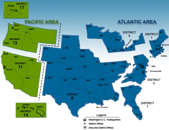
RNCs by Coast Guard Districts (map):
NameXMLSizeZip File Date Time* NameXMLSizeZip File Date Time* NameXMLSizeZip File Date Time*
01 CGDView331 MB02/13/2012 19:52:04  05 CGDView199 MB02/13/2012 20:00:38  07 CGDView258 MB02/13/2012 20:12:23
08 CGDView198 MB02/13/2012 20:20:53  09 CGDView261 MB02/13/2012 20:36:33  11 CGDView133 MB02/13/2012 20:42:38
13 CGDView176 MB02/13/2012 20:49:57  14 CGDView82 MB02/13/2012 20:55:34  17 CGDView471 MB02/13/2012 21:20:42

RNCs by States:
NameXMLSizeZip File Date Time* NameXMLSizeZip File Date Time* NameXMLSizeZip File Date Time*
AKView471 MB02/13/2012 21:44:41  ALView22 MB02/13/2012 21:46:01  CAView127 MB02/13/2012 21:50:13
CTView55 MB02/13/2012 21:52:13  DEView17 MB02/13/2012 21:53:05  FLView193 MB02/13/2012 22:00:29
GAView38 MB02/13/2012 22:01:52  HIView52 MB02/13/2012 22:03:47  IDView4 MB02/13/2012 22:04:01
ILView20 MB02/13/2012 22:04:50  INView18 MB02/13/2012 22:05:03  LAView92 MB02/13/2012 22:08:16
MAView98 MB02/13/2012 22:12:25  MDView61 MB02/13/2012 22:14:35  MEView115 MB02/13/2012 22:18:01
MIView130 MB02/13/2012 22:22:22  MNView27 MB02/13/2012 22:23:28  MSView26 MB02/13/2012 22:24:18
NCView52 MB02/13/2012 22:26:03  NHView27 MB02/13/2012 22:26:48  NJView64 MB02/13/2012 22:29:11
NVView5 MB02/13/2012 22:29:23  NYView144 MB02/13/2012 22:33:42  OHView40 MB02/13/2012 22:35:16
ORView64 MB02/13/2012 22:37:27  PAView17 MB02/13/2012 22:37:55  POView39 MB02/13/2012 22:39:08
PRView36 MB02/13/2012 22:40:29  RIView41 MB02/13/2012 22:41:45  SCView48 MB02/13/2012 22:43:21
TXView74 MB02/13/2012 22:45:38  VAView82 MB02/13/2012 22:48:14  VTView7 MB02/13/2012 22:48:30
WAView150 MB02/13/2012 22:53:11  WIView39 MB02/13/2012 22:54:40  Note: PO = Pacific Ocean

RNCs by Region (list):
NameXMLSizeZip File Date Time* NameXMLSizeZip File Date Time* NameXMLSizeZip File Date Time*
02View207 MB02/13/2012 23:00:13  03View212 MB02/13/2012 23:06:33  04View133 MB02/13/2012 23:10:32
06View132 MB02/13/2012 23:14:09  07View106 MB02/13/2012 23:17:35  08View146 MB02/13/2012 23:21:24
10View36 MB02/13/2012 23:22:39  12View115 MB02/13/2012 23:26:14  13View70 MB02/13/2012 23:28:33
14View157 MB02/13/2012 23:33:25  15View101 MB02/13/2012 23:36:23  17View161 MB02/13/2012 23:40:41
22View96 MB02/13/2012 23:43:41  24View72 MB02/13/2012 23:45:38  26View55 MB02/13/2012 23:47:17
30View170 MB02/13/2012 23:52:25  32View127 MB02/13/2012 23:55:44  34View166 MB02/14/2012 00:00:38
36View45 MB02/14/2012 00:02:07  40View80 MB02/14/2012 00:04:38   


* Zip File Date Time indicates when the zip file was created in Coordinated Universal Time.

Click Here for advanced data (index files and patches)

Resources:
Click RNC Dates for more information about the Print Date, NTM Date and various Cleared Dates.
Click Free Demo Software for links to several options.
Click Coast Survey's Inquiry page if you have comments or suggestions.

Privacy Policy  |  Disclaimer  |  NOAA's National Ocean Service  |  NOAA  |  U.S. Department of Commerce